Feel free to share
 Using this site means trees will be planted. ^.^
(Find out more)
Map creation guide part 2: Climates
In this second part we'll go over climates and a big chunk of what comes with it. We'll delve into how to setup climate zones based on ocean currents and prevailing winds, how mountains affect these zones, and we'll map out all these zones accordingly.
This part will be dense and likely take up a large chunk of your map creation time, especially if you wish to go very detailed, but it can be a great tool in the end to help build a realistic world in terms of adding civilizations, cultures and more.
Keep in mind that climate is incredibly complex and can vary greatly even within specific climate zones. The presence of lakes, forests, mountains and so much more can alter temperatures, rainfall, wind speeds, and so on. We're not going into these minute details, but merely paint the big picture overall. The details can then be filled in and altered afterward to fit specific (story) needs.
Like before, each step can be done using just paper, pencils, a ruler and an eraser, but in this step it definitely helps to have coloring pencils as you'll see below.
I also highly recommend making a copy of your map so far (if you're using paper instead of a digital version) and using one to map the climates as we'll do in this guide, then using this climate map as a reference for your main map.
Ready? Let's get started.
Prevailing Winds
The prevailing winds are surface winds that blow predominantly in a specific direction. This direction is determined by the rotational direction of the planet, but it gets more complicated than this. Let's first start with the three global circulation cells found on Earth and pretend the Earth doesn't spin. The image below will help illustrate everything.
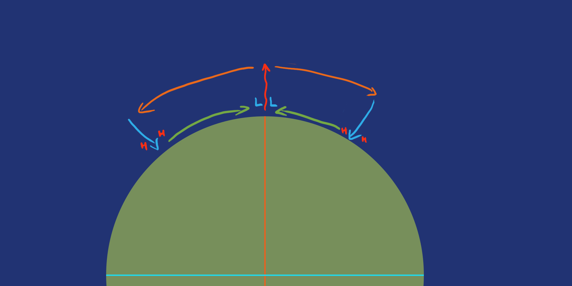
Warm air rises at the Equator (the red central line in the image) up to a height of about 15km/9 miles where it reaches the edge of the tropopause, which marks the limit of the lower atmosphere on Earth. At this point air cannot continue to cool any further, so it's pushed toward the southern and northern poles (marked by the orange lines) by the warm air that continues to rise from below. At around 30 degrees north and south respectively, this cold air is finally able to drop down (the blue lines).
The air rising at the equator leaves less and less air at the surface, which creates a low pressure zone. The air dropping down 30 degrees away drops on top of existing air, creating a high pressure zone. This high pressure wants to be relieved, and does so by replacing the air moving away at the equator, which in turn is what creates wind at the planet's surface (marked by the green line). This first cell is called a Hadley cell.
At the two poles, cold, denser air moves across the surface until at about 60 degrees north and south respectively, the air warms up enough to rise. Here it repeats the same mechanism as at the equator, creating the polar cells.
The space in between the polar cells and Hadley cells automatically follows similar patterns as low and high pressure zones demand to be equalized. They act like a gear and thus rotate in opposite directions to the Hadley and polar cells. These are the Ferrel cells.
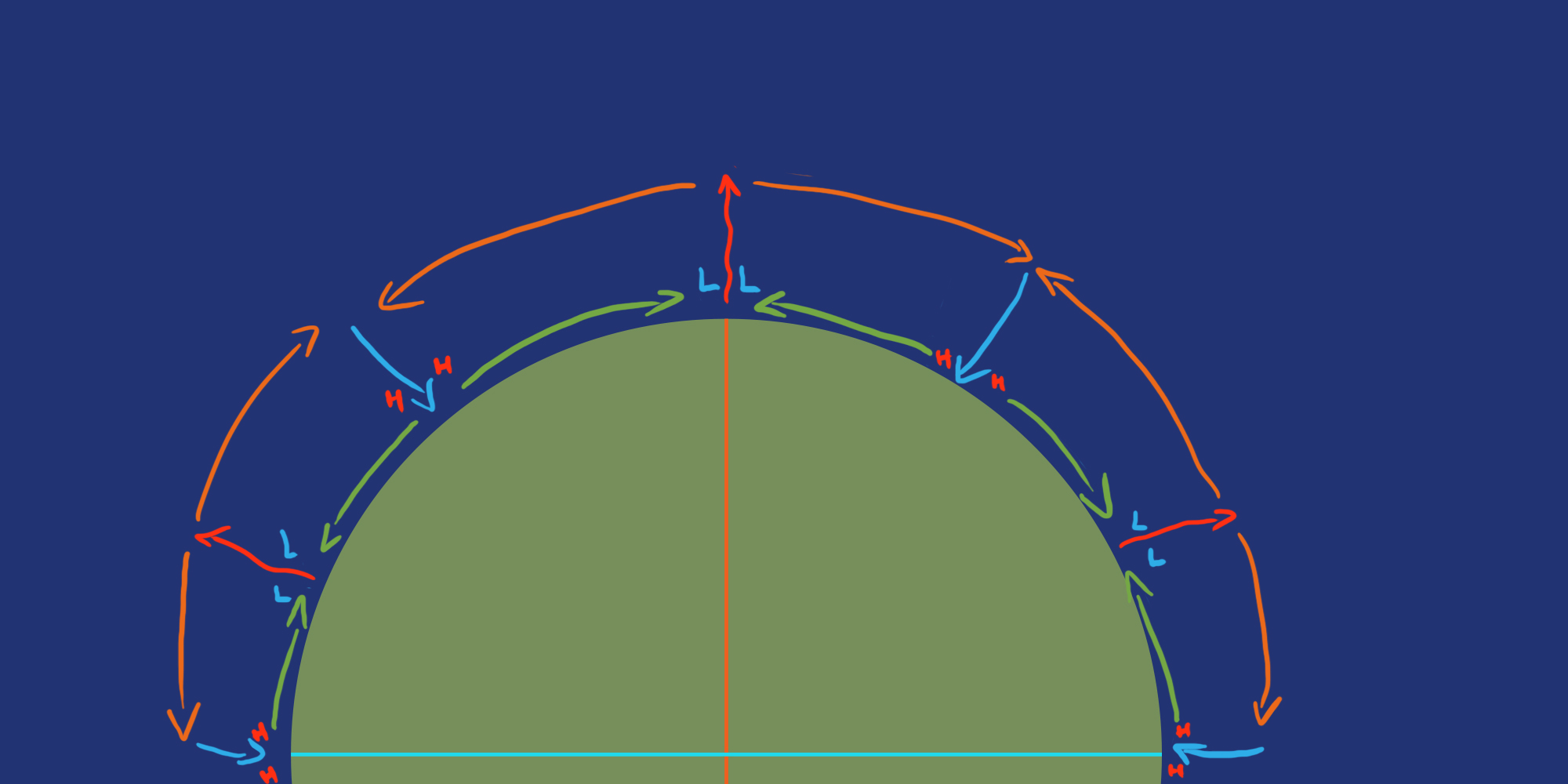
If the Earth didn't spin, this would be all there is to it and you'd end up with northerly and southernly winds, but obviously the Earth does spin and does so from west to east.
The Earth's surface at the equator rotates the fastest because it is away the furthest from the Earth's spin axis (the poles). The poles rotate the slowest. This means the air moving from the equator toward a pole moves from an area that spins fast to an area that spins slower.
This air isn't slowed down the same way anything on the surface is, so it rotates faster around the Earth than the surface below it, causing it to end up ahead of everything in a straight line above its starting point. To illustrate this, take a look at the image below.
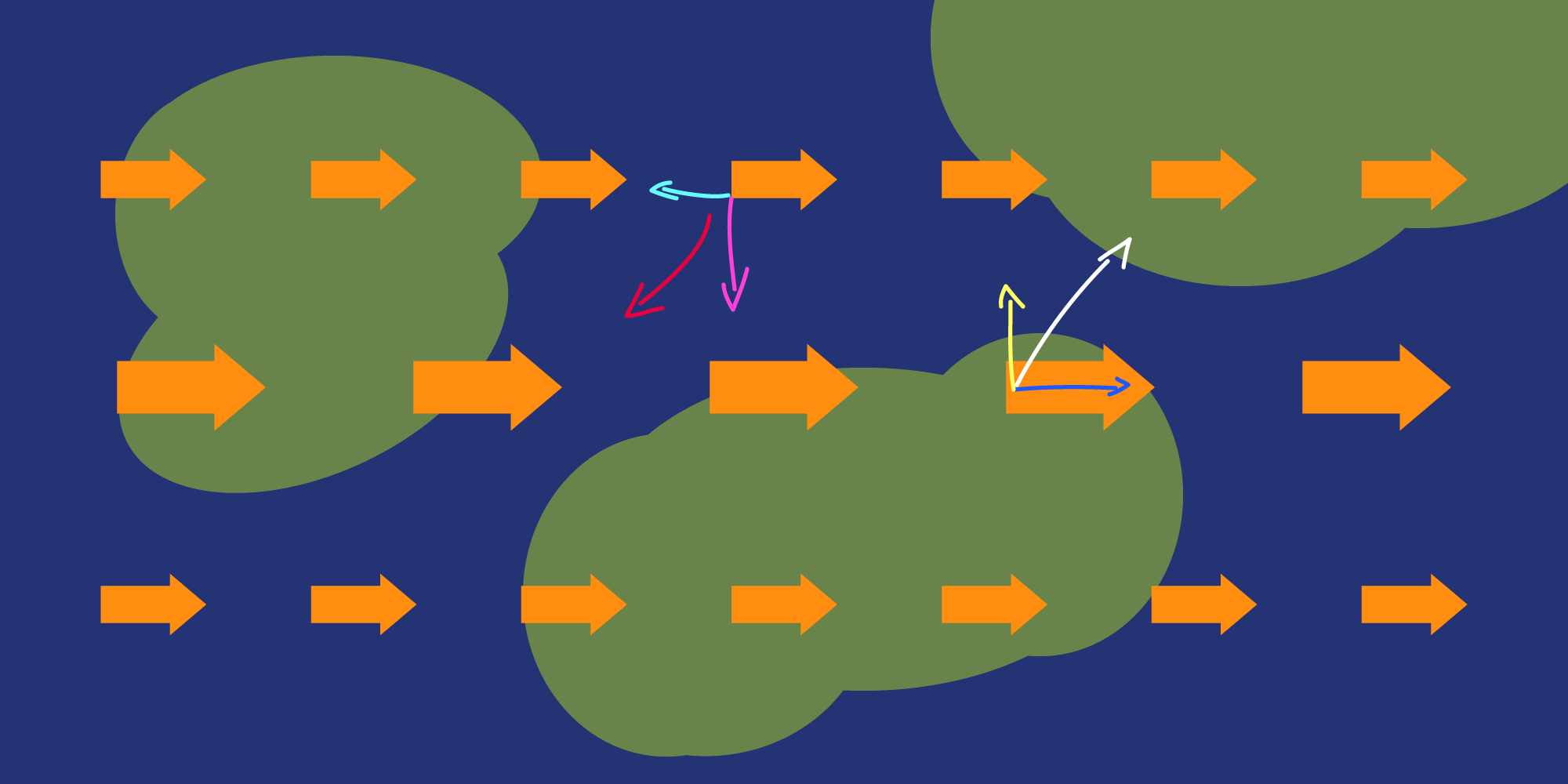
In the image above, the large orange arrows indicate the rotational speed of the Earth. The bigger arrows at the equator move faster than the smaller ones higher up (and thus nearer to the spin axis). Air moving from the equator upward has a higher velocity than the surface toward which it is drifting. Which means that as it goes up (yellow arrow), it also moves easterly (blue arrow) and ends up ahead of the point directly above the yellow arrow.
Anything moving from near the poles toward the equator has a lower velocity and thus will never be able to catch up to anything on the equator with the same starting point, meaning it'll end up west (cyan arrow) of the same point below it while moving down (pink arrow) and end up with a curved, westerly path (red arrow).
In this example, consider the white arrow to be the path air takes as it rises up from the equator higher into the atmosphere. As it cools down, falls to the ground at 30 degrees and is pushed back to the equator, it takes a path like the red arrow.
This is called the Coriolis effect and what this all means is that the surface winds going toward the equator (as shown earlier in the circulation cells) are deflected to the west. These are the trade winds.
The surface winds moving from the 30 degrees areas toward the poles are deflected toward the east (they're faster than the area they move to) and are called the westerlies (because they move from the west to the east). The cold air flowing away from the poles are, like the trade winds, deflected toward the west and are called the easterlies. These winds are important for our climate zones and for our ocean currents, but more on that soon.
With all this in mind you can create an image like below.
A last note, if your planet spins in the opposite direction, all these wind directions are mirrored. Everything else mentioned in this guide below is mirrored accordingly as well.
TLDR - Prevailing Winds
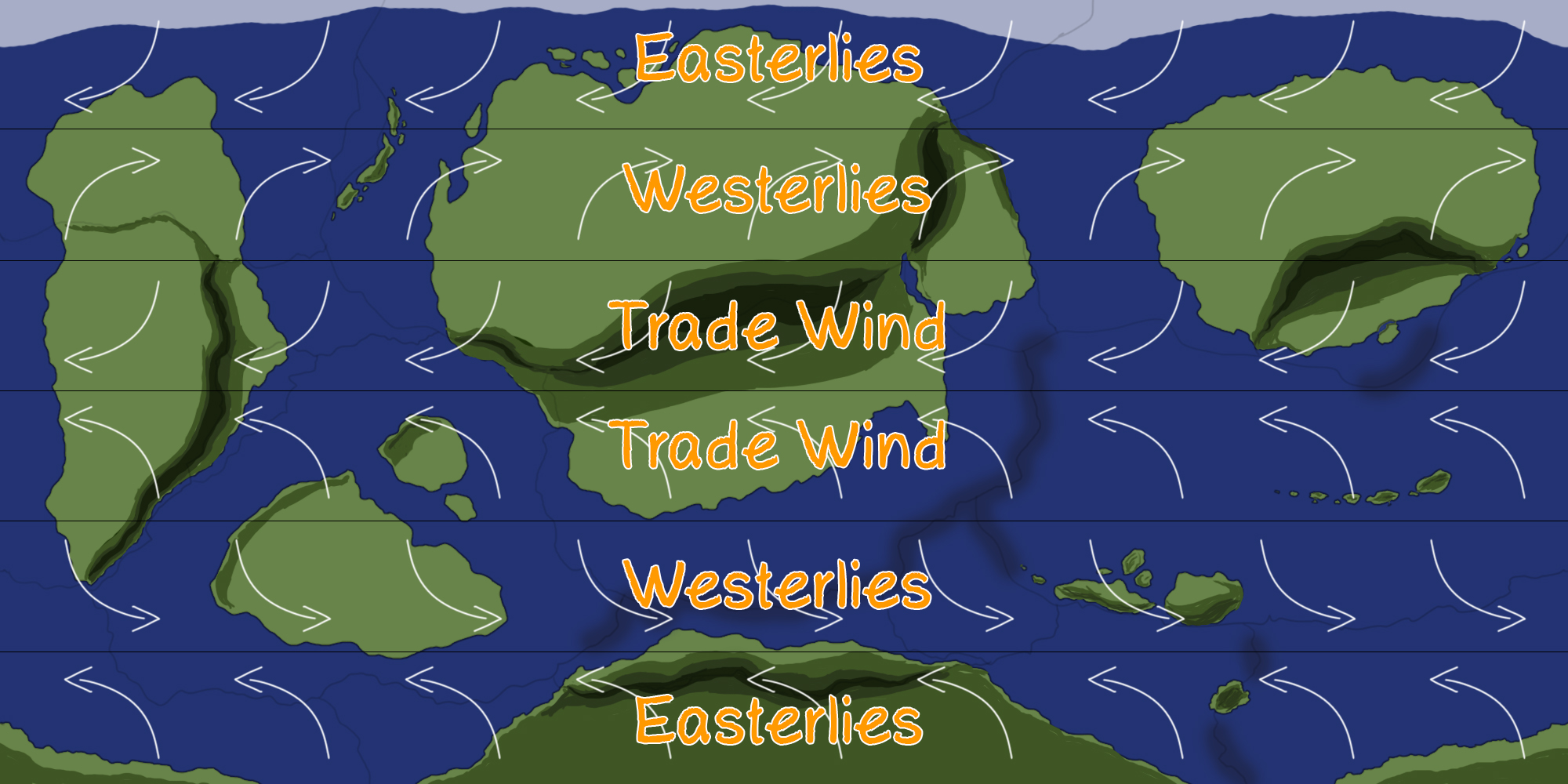
The rotation and heating of the Earth causes 3 circulation cells on each hemisphere. See the image above for the prevailing winds and their names, with black lines drawn at the equator, 30 degrees north and south, and 60 degrees north and south. Copy this to your map.
If your planet spins from east to west instead, mirror all the wind directions and mirror everything in the guide below accordingly as well.
Ocean Currents
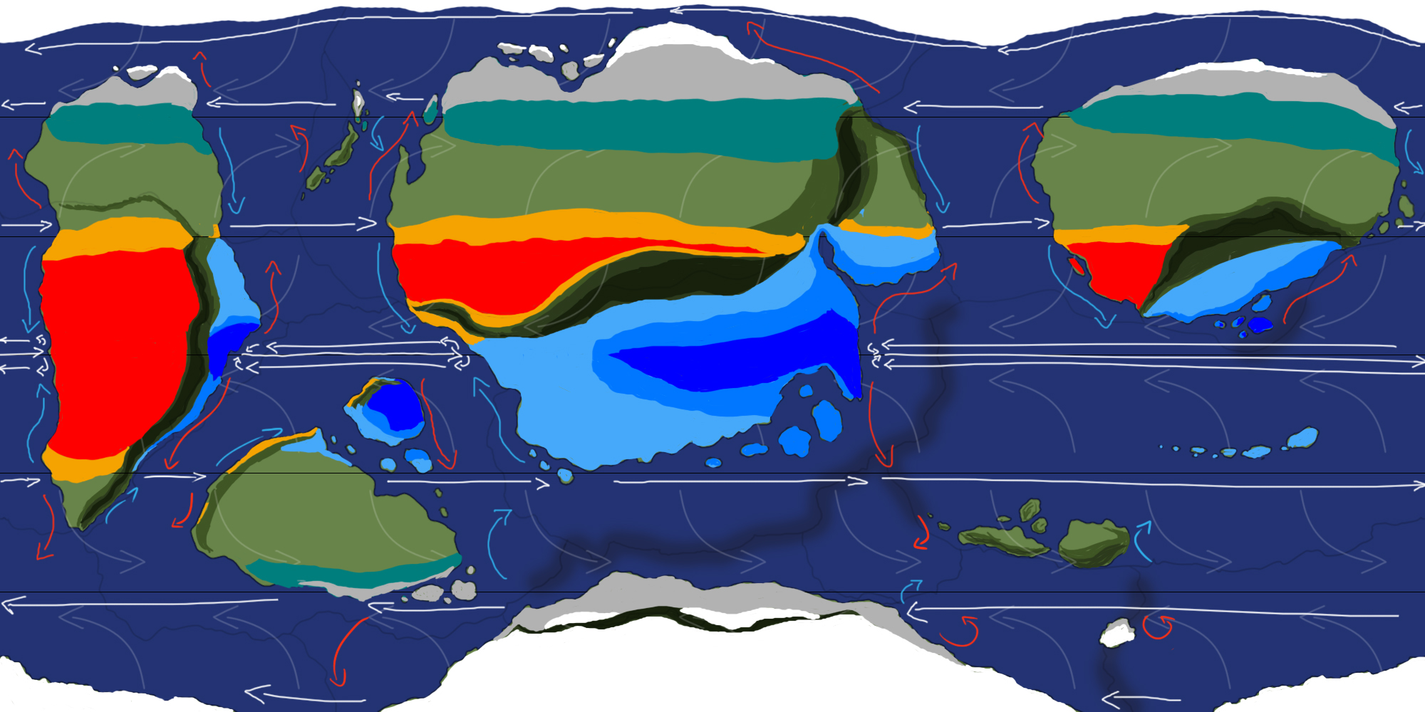
Wind and the Coriolis effect, among other factors, mean ocean currents. Very, very complex ocean currents. But we can simplify them a lot while still maintaining plenty of realism. The end result will look something like the image below, but I'll take you through it one step at a time.
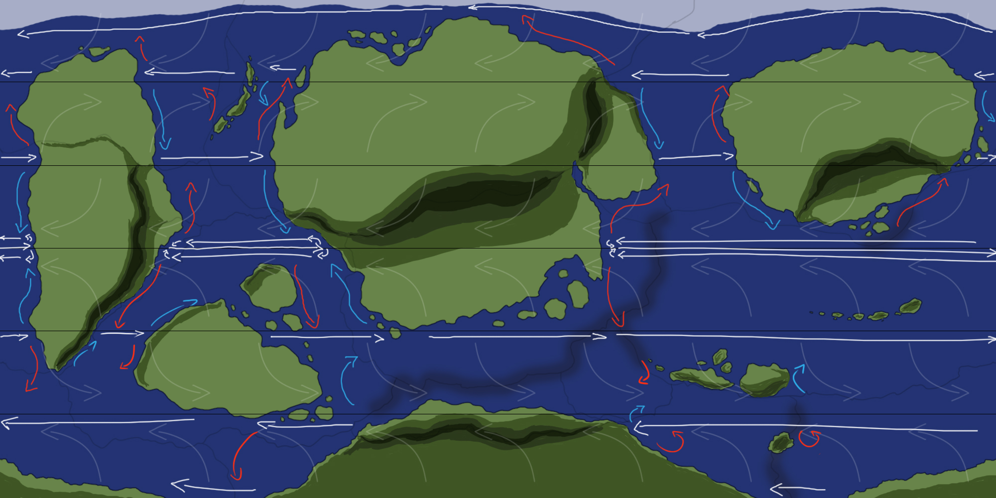
First start with the white arrows. At 5, 35 and 65 degrees north and south, draw a white arrow in the direction of the prevailing winds up until they hit a continent. You can do this at the poles along their shores as well.
Then, at the equator, wherever a white line hits a continent, draw a red arrow toward the poles up until it hits a white line at 35 degrees or a landmass diverts it.
When such a red line is drawn and hits a white line at 35 degrees, follow this line until it hits a continent, and draw a blue line back toward the equator lines. You've created your first loops. Ignore the red lines without a closed loop for now.
Wherever a 35 degree line hits a continent, draw a red line toward the poles. Again, up until it either hits the 65 degree white lines or a land mass diverts it. If it hits a white line, follow it again until it hits a landmass and draw a blue line toward the 35 degree line.
Finally, when a 65 degree line hits a continent, draw a red line toward the poles. Don't worry about following the lines at the poles, these loops don't need closing. The currents at the poles are complexer than this and are usually a bunch of smaller loops all around it.
Check your map for any unclosed loops. For every blue arrow between 65 degrees north and south, you want a red arrow in the same wind cell. So look for landmasses where ocean currents might be diverted to close any unclosed loops.
If any parts of your ocean are empty, add a loop if you see fit. Make it spin in the opposite direction of loops next to it. They're like mechanical gears.
Alternatively, fill this space up with islands or continental landmass, similar to how I filled up some parts of the map with more islands, like those at the bottom of the central continent (compared to the map of part 1).
If you wish, you can close the last loops at the equator by drawing white lines along the equator in the opposite direction of the winds, like on my map example.
Congratulations, you now have your ocean currents ready. In reality these would be far more complex, but this depends on more than just winds and rotation of the planet. They're too complex to have to bother with for the purposes of a fantasy map, but if you're so inclined you could of course research them further for an even more realistic map.
Cyclones
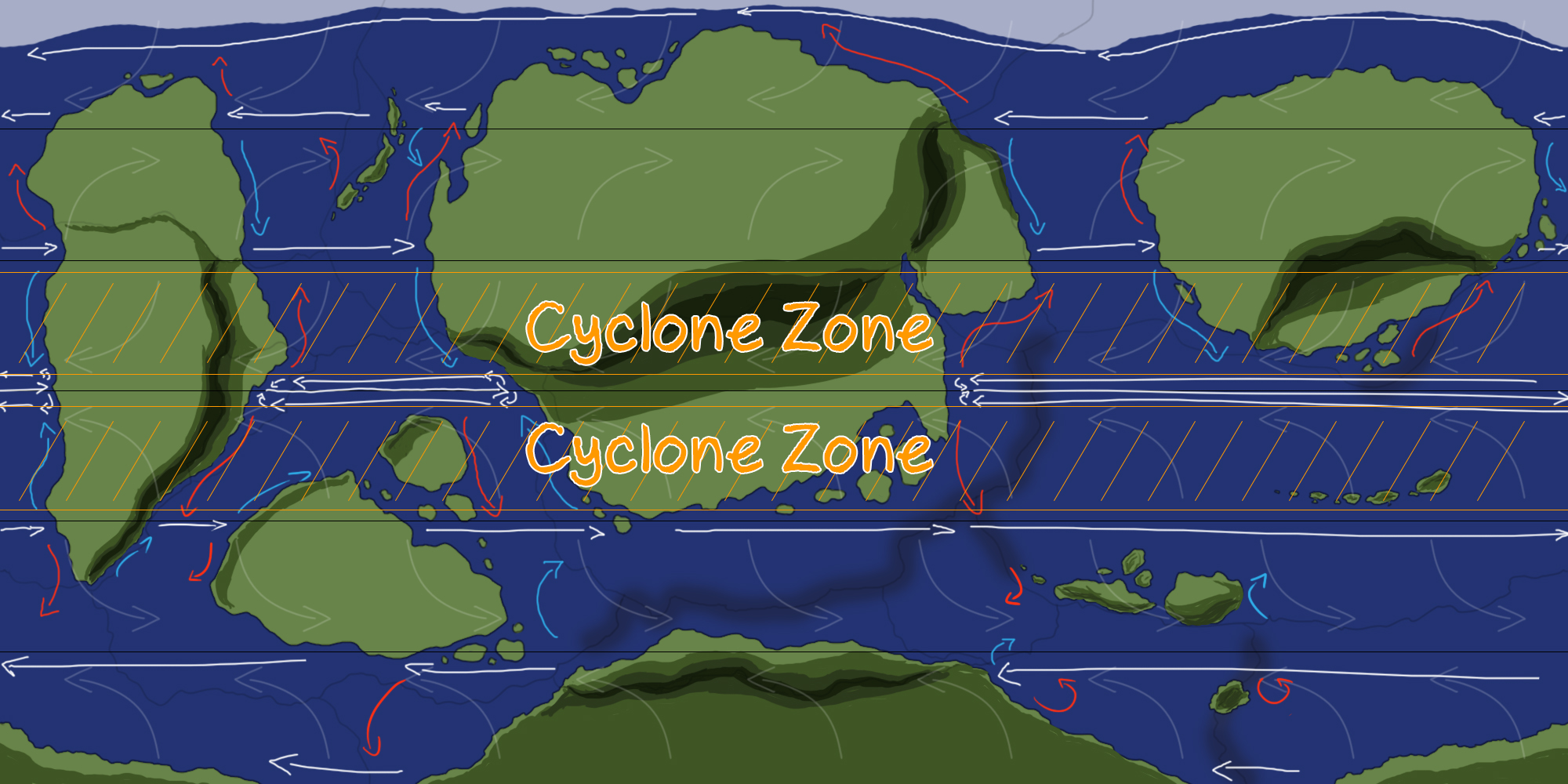
Tropical cyclones, as the name suggests, form in the tropical zone slightly north and south of the equator and above large bodies of warm water. On the image below I've marked the latitude limits of these zones. So, by looking at the large bodies of water within that zone we can see cyclones will likely form on the west side of the left continent, and in the ocean east of the central continent. It's also possible for smaller ones to form in between the central and left continents.
Areas where these cyclones will hit are thus the southern side of the right continent, the south and southeastern side of the central continent, and the east side of the left continent. This also means these areas are affected more by heavy rain and thunderstorms (including parts away from the coastal regions), which is important to keep in mind when we mark climate zones later.
On Earth, cyclones who form in the west Pacific Ocean are called typhoons. Those who form in the Atlantic Ocean or east Pacific ocean are called hurricanes. This doesn't really apply to a fantasy world, but you could make up your own terms or use a similar system if you wish.
Climate Zones
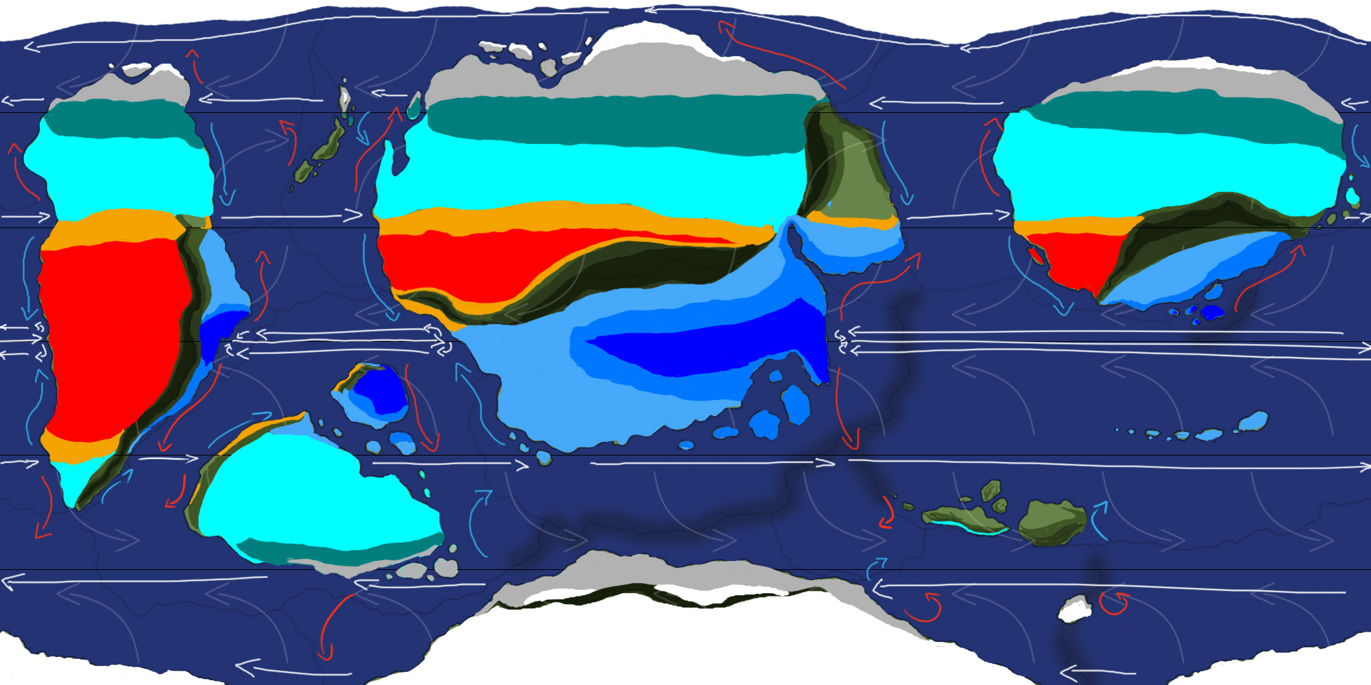
It's time to assign climate zones to our map. This is a complex step, but I'll take you through it one step at a time. But first, how will we do this? With the Köppen-Geiger climate classification system. Within this system, climates are divided into 5 main parts, and then further subdivided within. With this system, the Earth looks as follows:
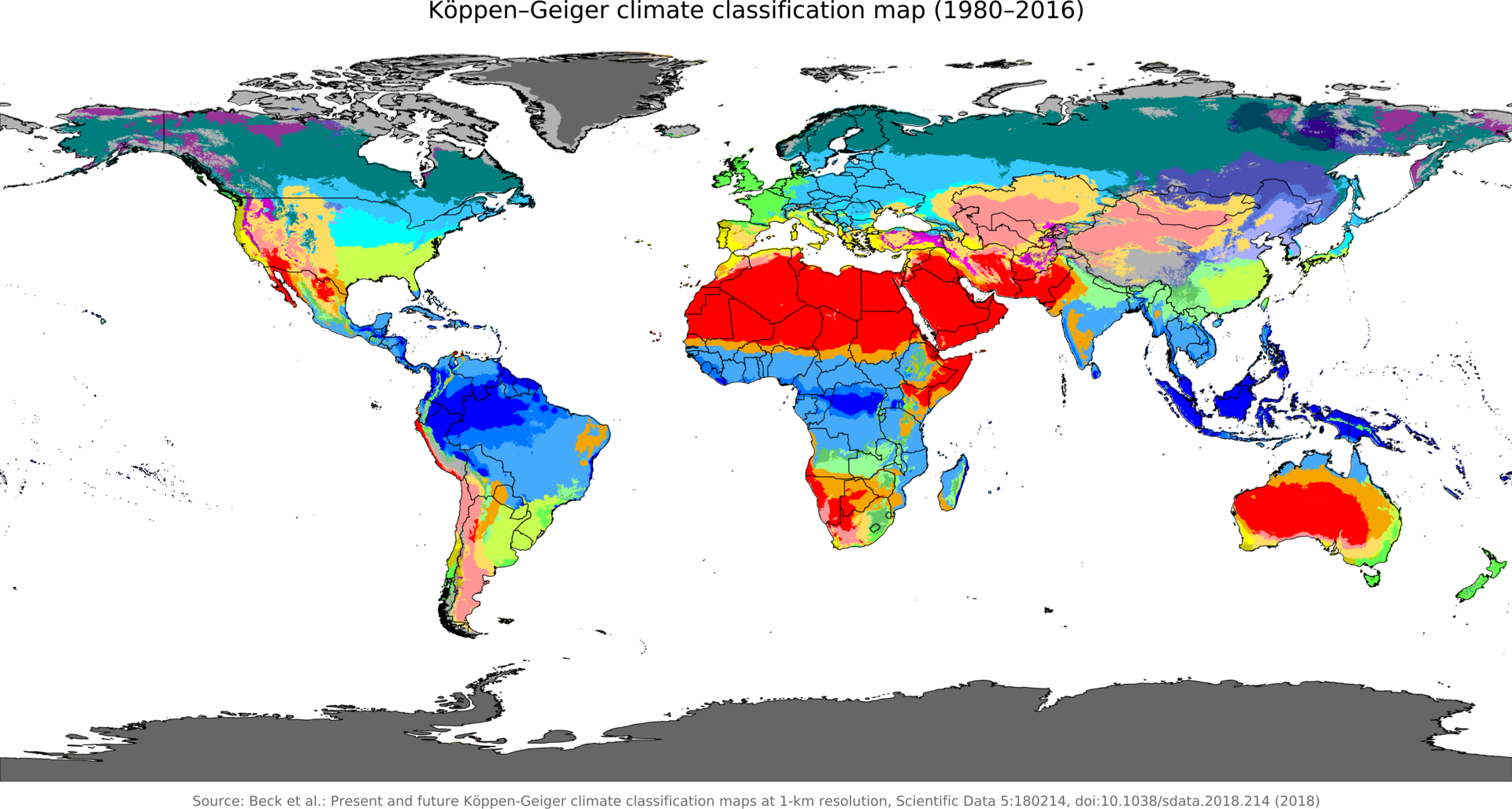
Each color represents a climate zone, but we're not going to use all of them yet. For now we're sticking to a broader picture, similar to what we did with ocean currents, and keep any exact details for later. But don't worry, the end result will still be a diverse and realistic representation of your fantasy world.
Things to keep in mind when assigning climates are:
- Rainfall in an area.
- Relatively warm ocean currents (red lines on the map) carry warmer, moister air and thus rain.
- Prevailing winds blowing against a mountain cause rain (thanks to orographic lifting) on this side, and a lack of rain on the other side.
- Summer and winter temperatures.
- Continents heat and cool faster than shores and oceans, meaning hotter summers and colder winters.
Polar Zones
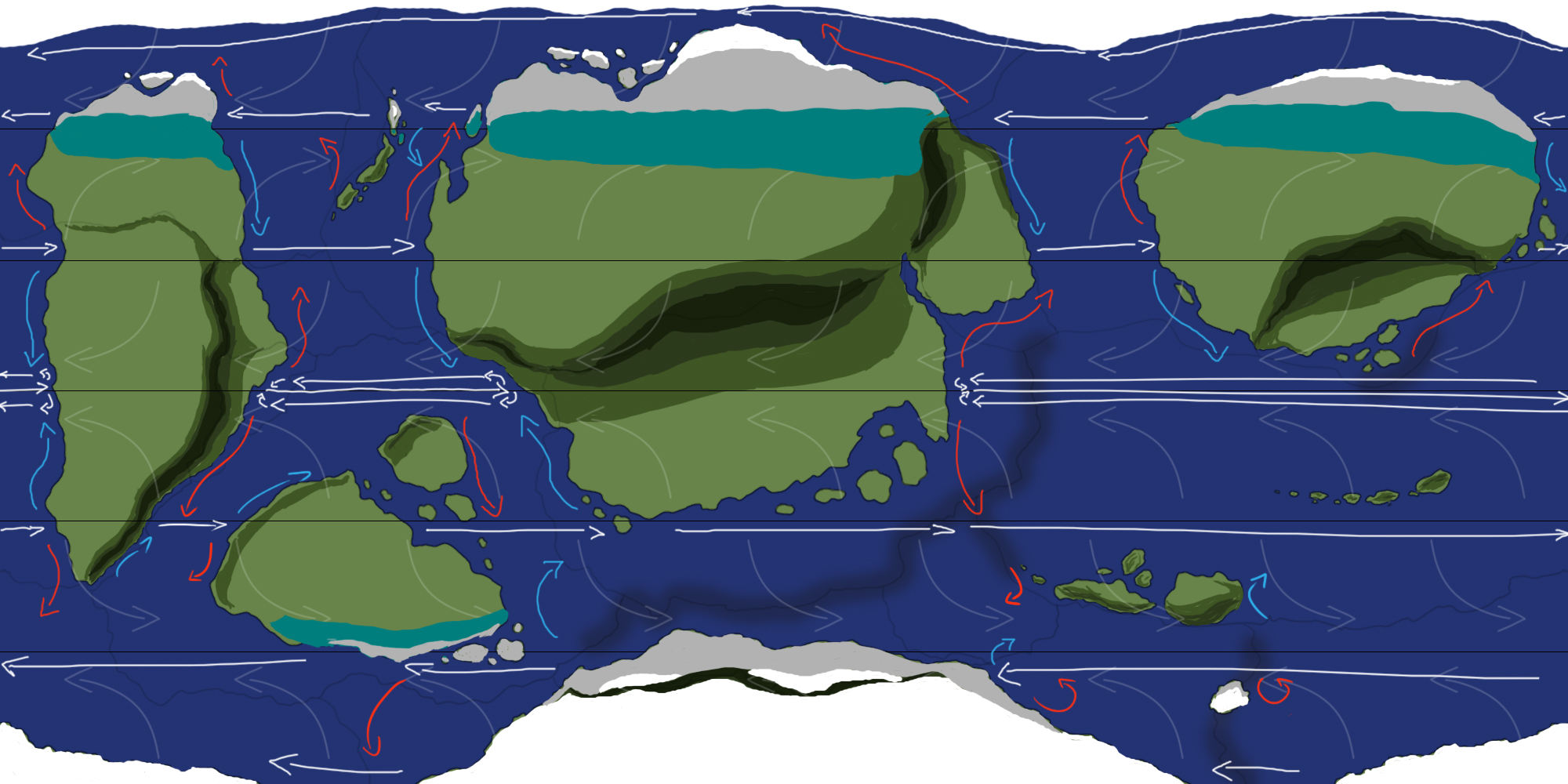
Let's start with the easy zones. Within the polar zone you only have 2 climates: The tundra climate and ice cap climate. But since subarctic climates sneak into these zones at times as well, I'm covering this one here too. First the ice caps.
Ice caps (in white on the map) appear between 65 degrees and 90 degrees on each pole. Their mean monthly temperatures never reach above 0C/32F and have very little precipitation. There's no vegetation here, only permanent ice.
On my map the biggest zones are the "north pole" and the continent to the south akin to Antarctica. The reason the bottom continent is almost entirely ice cap climate on my map is because little to no warm water is diverted from further away toward it and because the mountain range creates a rain shadow zone preventing even more heat and rain from accessing it.
Next up: Tundras (in gray). These are similar to ice cap climates, but have months where temperatures are warm enough to melt ice. This means there's no permanent ice cap, and vegetation is possible. Very little grows here however.
They're usually found between 60 and 80 degrees on both hemispheres, but these ranges can be more narrow depending on the shape of landmasses and the overall height. The higher the landmass, the more likely it'll be ice caps instead.
Then there's the subarctic climate (in blue-green). These are generally found between 50 and 70 degrees and usually on large landmasses and often poleward of humid continental climates (covered later in temperate zones). They're often home to extreme temperature fluctuations between summer and winter (thanks to the quick heating and cooling of their landmass). Canada, Russia and northern Europe are examples of this.
On my map they're found primarily on the northern hemisphere due to a lack of landmass within these latitudes on the southern hemisphere.
Tropics and Hot Zones
Next up, the zones around the equator. You'll either find tropical climates or hot, dry climates. Let's do the tropical ones first, starting with tropical rainforests.
Tropical rainforests (dark blue) are usually found within 15 degrees from the equator in regions with a lot of rainfall. Because hot air rises at the equator and then moves away, it creates a low pressure zone (as covered earlier). Low pressure zones are the zones with the most rain. Put yours wherever warm ocean currents meet continents along the equator. If there's an island or island chain, all of it can be covered in rainforest climate (like Indonesia).
On my map there are 2 main zones of tropical rainforest along the equator, with a potential few spots on the islands to the east. The island-like continent between the central and left continents is also home to a mountain range, adding to local rainfall and thus a potential home for a section of rainforest.
Next up, tropical savannas (light blue). They're found in similar zones as tropical rainforests, but have a dry season. As a result these zones often spread further than rainforest zones and feature a lower density of flora and fauna. For now, fill in the remainder of the continent sections that have tropical rainforests with tropical savanna up until any zone without precipitation and up to about 30 degrees north and south. On my map this means up to the mountain ranges.
Last, but not least of the tropical climates: monsoons (mid-tone blue). First and foremost, draw them as a thin border between savannas and rainforests. The main difference between a monsoon climate and a savanna climate is that a monsoon climate has either: a gentler dry season or more rainfall than a savanna. So with this in mind you can stretch zones who match this.
On my map a monsoon climate zone stretches along the mountain range on the left continent, and is also dominant on the southeastern islands of the central continent. Remember any typhoon season could bring vast amounts of rain far into a continent if conditions are right.
Monsoon climates are also found in areas where large landmasses and large oceans meet. Because of their different heating speeds, rainfall is often increased dramatically during the rainy phase of a season change. A real life example is India.
Keep in mind that a monsoon climate doesn't necessarily mean endless rains. In some places it means more rain than usual, in others it means semi-desert land is turned into lush, green lands.
Next up: hot deserts (in red). Hot deserts are (obviously) super hot and super dry. So anywhere cold ocean currents hit a continent, place a desert zone. On my map they're extra pronounced thanks to the rain shadows of the mountain ranges, especially on the left continent. As you can see, desert climates can stretch incredibly far, like on our own planet.
Last up: hot semi-arid zones. These are found as borders of hot deserts, usually at 30 degrees north and south. On my map they're also found on the islands between the left and central continent. They're in the rain shadow zones of the mountain ranges, but because these zones are on the shore and on relatively small landmasses surrounded by lots of water, these zones are mild enough for it to be semi-arid, rather than desert.
Temperate Zones
Time for temperate zones. We've technically already done one of them earlier when we did the subarctic climate zone. So all there's left is the humid continental climate zone. Note that both the subarctic and humid continental zones are normally further subdivided, but we're sticking to just 2 broad zones until the next part of the guide.
So, the humid continental zone (in cyan). Like subarctic zones, they have large seasonal differences in temperature. For now, simply fill in the entirety of each continent not already covered by other zones, with the exception of zones in the rain shadow sides of mountains. We'll add the other zones on top of this below.
Continental and Cold Desert Zones
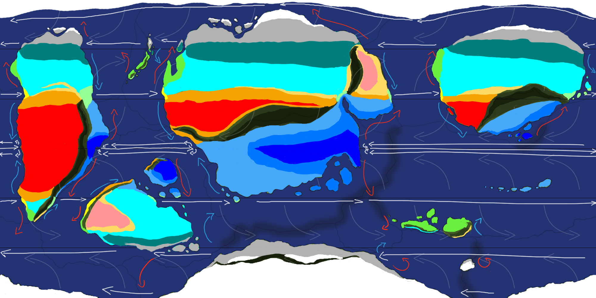
Things get a little trickier here. Let's start with the Mediterranean climate zone (in yellow). They're characterized by hot summers and wet winters, but their hot summers are in part due to the subtropical ridge migrating further away form the equator. The subtropical ridge is the area where the Hadley cell and the Ferrel cell meet (at around 30-35 degrees north and south) and where you'd find an almost constant high pressure zone. This zone moves further away from the equator in summer, making a larger area dry during this time, and retreats back in winter. The zone no longer covered by this ridge now gets rain again, and a Mediterranean climate is born.
For there to be rain during these winters, you need warm ocean currents carrying the humid air. So Mediterranean climate zones are usually only found on the west side of continents and only along the shorelines.
Next up: oceanic climates (bright/lime green). Oceanic climates have cool summers (around 22 C/72 F) and mild winters (usually above 0 C/ 32 F). They also often lack a dry season. As a result, these are often found on coastal regions with warm ocean currents, but can be found further inward as well. For now, add them on coastal regions with warm ocean currents and with a latitude of more than 35 degrees. You'll see you'll find them above the Mediterranean zones a lot, though not exclusively.
Now we go for humid subtropical climates (pastel green). These are usually found between 25 and 35 degrees, on the east side of continents, and are often next to tropical climates (savanna/monsoon/rainforest). They have hot, humid summers and cold to mild winters. They're usually found along the coasts, but can extend far inland. This usually happens when there are large temperate zones north of these coasts, and tropical zones south of these, resulting in a subtropical buffer zone.
You'll notice they're often on the opposite side of Mediterranean zones on their respective continents, but nearer to 30 degrees than 35.
Then there's cold deserts (dark pink). Like hot deserts, they feature hot summers and cold, dry winters. You'll find them from 30-35 degrees onward toward the poles, and usually in temperate zones where there's little rainfall. This is usually in the rain shadow zone of a mountain range, like on the smaller continent between the larger central and left ones, and on the left side of the central continent.
Last, but not least: cold semi-arid zones (light orange). Like their hot counterparts, these are found at the edges of cold deserts as a type of transition zone. They're also found in elevated parts of temperate zones and in continental interiors far away from large bodies of water. They often share borders with Mediterranean and/or humid continental zones.
Mountains
Mountains are a bit trickier as their climates change drastically depending on their height. But in general, you want to put an oceanic climate on the rain side of mountains bordering tropical climates, or a cold desert climate if the mountains are really high/on their highest points.
Mountains on the rain shadow side around the equator usually have either a hot or cold desert climate depending on how high they are. A tundra climate is also possible if they're high enough (like in Peru).
In the temperate zone, mountains more often than not have a cold desert or cold semi-arid climate on the rain shadow side. Depending on the height of the mountains, the rain side may have an ocean climate or a cold semi-arid or cold desert climate as well. If the mountains are really high, a tundra climate is possible (like the Himalayas).
In the polar zone, mountains generally have a tundra climate at the lower latitudes and altitudes, and an ice cap climate at higher ones.
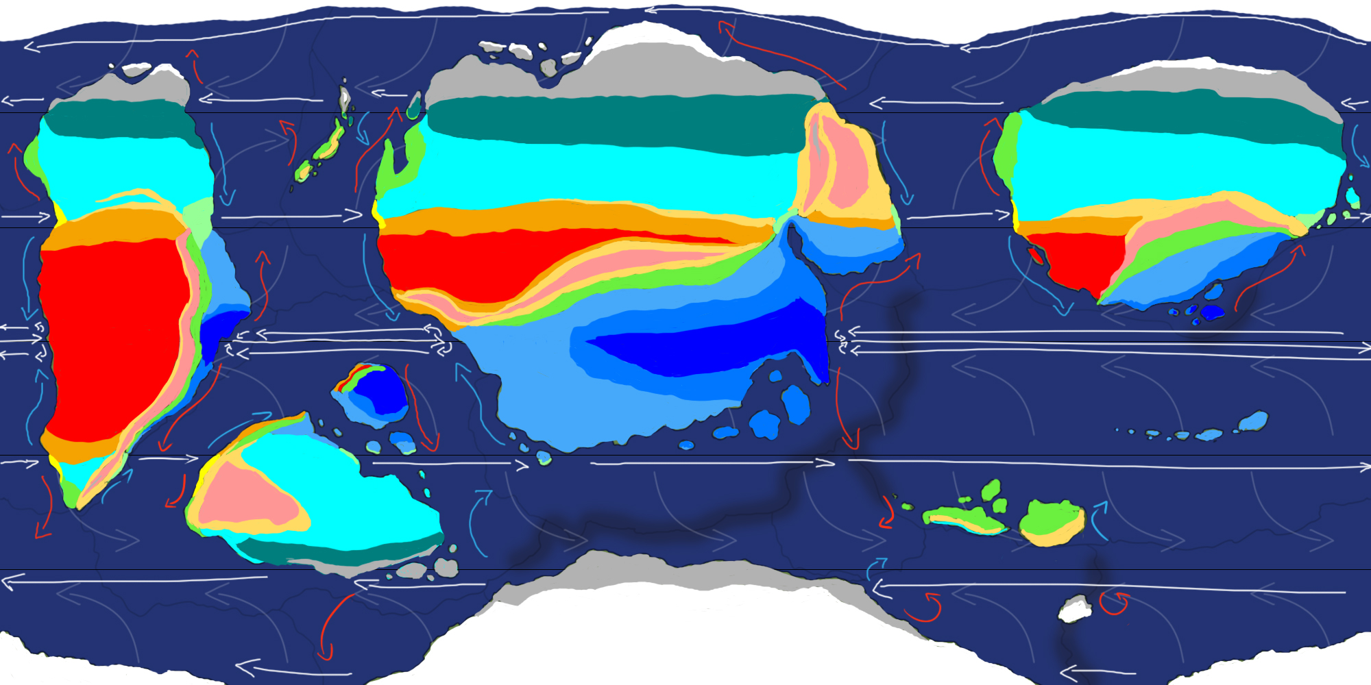
Other colors
As mentioned before, I ignored some of the other colors present in the Köppen-Geiger model (for now). The other colors are usually there to distinguish between different temperature ranges. For example, instead of just one Mediterranean climate like on my map, the Köppen-Geiger model divides them further into Hot Summer, Warm Summer and Cold Summer Mediterranean climates.
The same is true for the humid continental climate, except this one is divided into six based on whether they have a dry summer, dry winter or no dry season, and a hot or warm summer. I will likely add these in a later part of this guide, but for now the map as it is will work great for fine tuning purposes and could be all that's needed for a story telling point of view in a realistic enough world.
Summary
In the next part we'll add a lot of natural elements, like rivers, lakes, small islands and perhaps even small seas to change local climates within the large continents and fine tune a lot of the zones to create a diverse world. But before this, here's a table with all the climate zone information covered so far. In the next part we'll also delve into their individual flora and fauna ranges.
| Zone Type | Latitude Range | Summers | Winters | Extra |
| Rainforest | 0-15 degrees | Hot and wet | Hot and wet | |
| Monsoon | 0 to 25-30 degrees | Hot and very wet | Hot/Warm and dry | Often as a rainforest border |
| Savanna | 0-30 degrees | Hot and wet | Hot/Warm and dry | |
| Hot Desert | 0-30 degrees | Very hot and dry | (Very) hot and dry | Also in mountain areas |
| Hot Semi-Arid | 10-35 degrees | Hot and mostly dry | Warm/hot and mostly dry | Also in mountain areas |
| Humid subtropical | 25-35 degrees | Hot and humid | Mild and dry | East coasts of continents |
| Mediterranean | 30-35 degrees | Hot/warm and dry | Warm, wet | West side of continents, along shores |
| Humid Continental | 30-60 degrees | Warm, moderate rainfall | (Very) cold, mostly dry | 30-60 degrees |
| Cold Desert | 30-60+ degrees | Hot/warm and dry | Cold and dry | Also in mountain areas |
| Oceanic | 35-60 degrees | Mild, wet/moderate | Mild, wet/moderate | Often poleward of Mediterranean |
| Cold Semi-Arid | 35-60+ degrees | Warm and mostly dry | Cold and mostly dry | Also in mountain areas |
| Subarctic | 50-70 degrees | Mild/cold and moderate rainfall | Cold/very cold and mostly dry | |
| Tundra | 60-80 degrees | Cold and mostly dry | Very cold and dry | Vegetation is possible |
| Ice Caps | 65-90 degrees | Very cold and mostly dry | Very cold and dry | Permanent ice and no vegetation |